Dinefwr Park & Newton House
The Rhys dynasty once ruled over the mediaeval kingdom of Deheuberth which, at its peak, took in large parts of modern day Carmarthenshire, Pembrokeshire and Cardiganshire with Breconshire thrown in for good measure. All that remains of the mighty Dinefwr lands today, one thousand years later, is the small (though perfectly formed) Dynevor Park in Llandeilo. Crossing our traffic-choked roads, in this no longer rural little town, few today realise how recently our residential surroundings were once just pasture and woodland, criss-crossed by a network of tinkling streams and babbling brooks. Tarmac, concrete, bricks and mortar have since covered the fields with the fabric of an urbanized environment; the streams have been culverted underground and out of sight, now reaching their destinations in the Towy and Cennen rivers undetected by the people who scurry about on top. The history of the mediaeval dynasty of Rhys is very well recorded but less so is what happened to the family after they were dispossessed in 1277 by Edward the First, who finally subdued all of Wales by 1284.
Today's Dynevors claim their descent from these same twelfth century Lords Rhys. The mediaeval dynasty however remained dispossessed for 200 years until a Welsh king, Henry Tudor (Henry the Seventh, who also claimed descent from the Lords Rhys), seized the English throne from Richard the Third in 1485 and restored the lands to the latest member of the family line, Rhys ab Thomas. Rhys had raised an army in support of Henry in 1485 so the restoration of his lands was his reward, as was a knighthood granted him by Henry. The next king however, Henry the Eighth, reverted to type and took the lands back from ab Thomas's grandson, Rhys ab Gruffydd, who was accused of plotting with the king of Scots to overthrow Henry and make himself ruler of Wales. Part of the evidence against him was that he had sought to stress his links with the ancient Welsh kings by adopting the name Fitzurien (still part of the Dynevor family name today.) The charges were preposterous and fabricated but it was Rhys's misfortune to be guilty of a crime greater even than treason in Henry's eyes: owning extensive estates and wealth when Henry was in permanent need of money. Rhys's fate was sealed and he was executed in 1531, having no chance of justice at the hands of a man who would soon behead two of his own wives (Anne Boleyn in 1536 and Catherine Howard in 1542). Henry's daughter, Queen Mary (reigned 1553 - 1558), restored some of the lands to the Rhys family and Charles the First (reigned 1625 - 1649) finally restored all the lands to them (who by now had anglicized their name to Rice). A 19th century historian descibes these events thus:
The Dynevor estates were given by Henry the Seventh to Sir Rhys AB Thomas, and descended with his other possessions to his grandson Rhys Ab Gruffydd, from whom, through an act of the most cruel injustice, they again reverted to the crown, in the reign of Henry the Eighth. Rhys's ancestors had been in the habit of occasionally adding AB Urien, or Fitz Urien, to their names, in conformity to the general Welsh practice, in order to show their descent ['Ab' and 'Fitz' both mean 'son of'']. This designation, after being disused for some time, was again adopted, probably in a vain frolic, by young Rhys. The circumstance being reported to the king, and being associated with the immense possessions and unbounded popularity of the family, was construed [by Henry the Eighth] into a design to assert the independence of the principality, and to dissever it from the English government. It was also supposed, without the shadow of proof, that this was part of a concerted plan to depose King Henry, and bring to the English throne James the Fifth of Scotland. To increase the absurdity of the whole business, the plot was said to be founded on an old prophecy, that James of Scotland with the bloody hand, and the Raven, which was Rhys's crest, should conquer England. On such frivolous grounds was this young chieftain, himself one of the first commoners in the realm, and connected by marriage with the family of Howard, arraigned for high treason, found guilty, and beheaded.
On the accession of Queen Mary, his son, Gruffydd AB Rhys, had his blood restored, and received back part of the estates; and Charles the First relinquished to Sir Henry Rice all that were at that time of them in the hands of the crown. The estates thus restored to the family were valued at about three hundred pounds a year; these constitute their present Welsh territories, and are all that remain to them of the princely possessions of their ancestors.
The house of Dynevor has always held considerable influence in the county [ie Carmarthenshire], and has in several instances furnished its parliamentary representatives. George Rice, who died in 1779, married in 1756 Lady Cecil Talbot, only child of William, Earl Talbot. This nobleman was afterwards created Baron Dynevor, with remainder to his daughter, who, on his death in 1782, became Baroness Dynevor. On the death of her mother in 1787, she took the name and arms of De Cardonel, which are still borne by the family. Her ladyship died on the 14th of March 1793, and was succeeded by her eldest son George Talbot Rice, the present Baron Dynevor [in 1815].
The Dynevor Title
The Rhys (or Rice) family may have had their lands at least partially restored in the Tudor and Stuart reigns but the title that once went with them in medieval times was not part of the deal. The modern Dynevor peerage goes back only to 1780 when Charles Fitz Uryan Rice was created the 1st Baron Dynevor (again, anglicised spellings were more in keeping with the fashion of the day so Dinefwr had to go). Walter Fitz Uryan Rice became the 7th Baron Dynevor on the death of his father in 1911 but by 1916 being Welsh had come back sufficiently into fashion for him to change the name Rice by royal assent back to Rhys! (But not before a street in Betws built on Dynevor land had been named Rice Street after him in 1906.)
Newton House
An 18th-century landscape park, enclosing a medieval deer park, Dinefwr is home to more than one hundred fallow deer and a small herd of Dinefwr White Park Cattle. A number of scenic walks are available including access to Dinefwr Castle, with fine views across the Towy Valley. There is also a wooded boardwalk, particularly suitable for families and wheelchair users. Newton House, built in 1660, but now with a Victorian façade and a fountain garden, is at the heart of the site. It has two showrooms open to the public, a tea-room which looks out onto the deer park and an exhibition on the history of Dinefwr in the basement. There had been a manor house on the ancestral estate at Dynevor Park since the 15th century but It was in 1775, at the time of the creation of the 1st Baron, that the grounds were remodelled by Capability Brown in the fashion of the time - a carefully-controlled 'wilderness' of sweeping parkland punctuated by groups of towering trees. Stroll back through the deer park and you soon arrive at Newton House (or Plas Dinefwr), the 'new' castle. Although the present Newton House dates back to 1660 and Sir Edward Rice - the great-great-great-great-great grandfather of the present Lord Dynevor - the house has substantial 18th-century and Victorian Gothic additions. Newton House has had something of an unhappy recent history. It was sold by the present Lord Dynevor in 1974 and suffered badly, falling into near ruinous disrepair. It was occupied by squatters for many years and was stripped of many of its original features. (No more than two people at a time are allowed on the top floor because the structure has been weakened by the removal of beams and joists for firewood!)Mercifully, both the mediaeval castle and Newton House have recently been restored by Cadw and the National Trust respectively, who now run the park, its buildings and a tea shop. Dynevor Park is also open to the public. Check the National Trust website for opening times, admission prices etc.
Since being restored to something resembling its former glory, Newton House has become an important feature of Llandeilo's cultural life, providing a superb setting for concerts and exhibitions as well as being licensed for civil weddings. The National Trust acquired the deer park and the outer park at Dinefwr in 1987. Newton House was purchased by the Trust in 1990 having been through several hands since first sold by Lord Dynevor in 1974. The East Drive was acquired in 1992. The generosity of the Heritage Lottery Fund facilitated the purchase of Home Farm and Penparc in 2002 and the site of a Roman fort has since been discovered on Home Farm, so an exciting prospect lies ahead when the site, hopefully, is excavated in the near future (see below). Dinefwr is now 286 hectares in extent (707 acres).
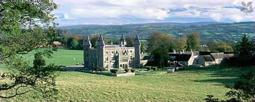
Photo Credit: National Trust Photographic Library/Andrew Butler. Property: Dinefwr (in Carmarthenshire).
Caption: Newton House and the surrounding lands of Dinefwr Park viewed from the north west. The parkland was landscaped by Capability Brown in 1775 century and the house built in Victorian-Gothic style between 1856 and 1858. Reference: 055432.
The organisation responsible for the Welsh architectural heritage is CADW (Cadw means 'to keep' in Welsh) who describe Newton House thus:
Newton Mansion continued to be occupied by the Rice (Rhys) family and was partly rebuilt between 1595 and 1603, again in c.1660, and in c. 1757-1779, and then in its present form in 1856-1858 by Richard Kyrke Penson, retaining many features from c.1660. The present landscape was emparked between c.1590 and c.1650 (Milne 1999, 6). The park walls were completed in c.1774 and enclosed a large landscaped area of over 200 hectares with a small formal garden, walled gardens and a suite of domestic structures. There are some remains of underlying landscapes, including an east-west terrace that may represent part of the Carmarthen-Llandovery Roman road, and traces of roads and trackways that may be Roman and/or Medieval. A Roman milestone and a coin hoard have also been recorded near Dinefwr Castle while sherds of amphorae and Samian ware have been found in the vicinity of Dinefwr Farm (Crane 1994, 6). The central part of the area includes the old parish church of St Tyfi, Llandyfeisant, which has Medieval origins. It is now redundant and used by the Wildlife Trust West Wales; the record.....of 'Roman tesserae' beneath the church appears to be entirely erroneous.
When the 7th Baron Dynevor died in 1956, his son Charles Arthur Uryan succeeded to the title to become the 8th Baron. He however died in 1962 (he is buried in Llandyfeisant Church on the Dynevor estate in Llandeilo). The resulting death duties from two deaths in quick succession plunged the estate into crisis. Large parts of land were sold to pay the duties and even the Dynevor Estate's office building on College Street had to close, being sold as a private residence in 1966. Purpose built in 1914, its strong room had eighteen inch thick walls and heavy steel fire-proof doors where plans, deeds, registers and other legal documents and valuables could be stored. This had been the office from which the three generations of the Bishop family had managed Lord Dynevor's extensive land holdings and business transactions. The sale of most of his land to pay death duties meant there was now very little land to be managed or business to transact.
Castle Woods and Llandyfeisant Church
Web Site: The Wildlife Trust of South and West Wales
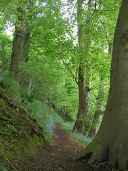
Newton House and most of Dynevor Park are owned and managed by the National Trust but the modern-day park also includes Castle Woods, Llandyfeisant Church and Dinefwr Castle which comprise the southern edge of the park, overlooking the river Towy. These are all owned by another public body, the West Wales Wildlife Trust, though another public body again - CADW, the Welsh ancient monument organisation - maintains Dinefwr castle on their behalf.The Castle Woods Nature Reserve has been described as "...one of the most exciting woodlands in South Wales" by no less an authority than Peter Crawford, a senior producer with the BBC's Natural History Unit, in his book 'The Living Isles.' "The woodland is primarily oak and wych elm," he writes. "The shrubs and ground cover are outstanding with cherry, holly, spindle, dog violet and the parasitic toothwort. Lichen communities are of importance and include the rare lungwort. Overlooked by the romantic Castle of Dinefwr the fine old parkland has a herd of fallow deer. The mature trees attract woodpecker, redstarts and pied flycatchers. In winter the water meadows draw large numbers of ducks."It's every bit as good as it sounds. The woods were purchased by the Wildlife Trust West Wales in 1979 and extend for dozens of acres along the steep slopes which rise from the Towy meadows up to the old Dinefwr Castle and to Penlan Park.
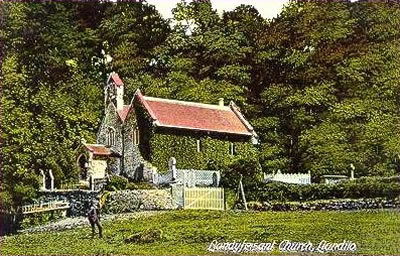
The main access is from Penlan Park, but it's also possible to walk down the lane alongside the stone bridge over the Towy, following the marked paths indicated by the Badger footprint signs. Before long you'll come across Llandyfeisant Church, which lies in a delightful, sylvan, secluded setting at the heart of the reserve. This was regarded as the family church of the Lords of Dynevor, but had fallen into near-dereliction by the 1980s. It ceased being used for worship in 1961 when its font and stained glass window war memorial were removed to nearby St Teilo Church for safekeeping. This was not the first time, though, that the church had been allowed to fall into a ruinous state, and nor can our restless century carry the blame alone for the neglect of our architectural heritage, as the following inspection of Llandyfeisant church aptly demonstrates:
Llandefoysaint
The Church consists of two aisles, the roof of the north aisle has no tiles upon it, the Timber which has been very good, & still might be of use, is expos'd to rot in the weather. The other aisle is very much decay'd in the tiling. In fair weather the Minister that assists at Llandeilo reads prayers here once every Sunday, but in wet weather he is forc'd to omitt them there being no convenient place in the Church for keeping him or the people dry. No Bible, Common-Prayer Book, Homilies, Canons, Table of Degrees, nor Register Book. My Lord Carbery who holds the Tithes as Tenant to the Bishop of Chester allows 40 shilling a year to the Minister. Question. whether any preaching? I believe not.
The date of the above 'visitation' (ie, inspection)? July and August of 1710! But by the 19th century the farm workers, retainers and servants of the rebuilt Newton House and Dynevor estate provided a sizeable congregation for Llandyfeisant church, which was completely rebuilt in the late Victorian period, as described in this survey by the Welsh ancient monument organisation, CADW :
Small stone church of medieval origin but almost entirely rebuilt in later Cl9, possibly to designs by R Kyrke Pearson, architect of Oswestry who redesigned Newton House for Lord Dynevor. Plan of unified chancel and nave with medieval (?) South aisle set back to left.....Church of moderate architectural interest in an exceptional location at Dynevor Park. Fine steeply sloping burial ground with old headstones.
The church has since been restored with the help of unemployed labour from the Manpower Services Commission and served briefly as an information centre and shop in the 1990s, though it is currently locked. We may be seen as a more secular age than back in 1710 but our lack of piety hasn't stopped us caring for our religious heritage any less. A few yards away from the church lie the ruins of the former vicarage, open to the elements now, and untended graves scattered under the slowly encroaching trees lend the scene a melancholy air tinged with a little mystery. Not somewhere for those of a nervous disposition to find themselves as nightfall approaches, either.
Cadw Report on Dinefwr Castle and Dynevor Park
Dinefwr Park and Newton House
GRID REFERENCE: SN 617225
AREA IN HECTARES: 229.20
Historic Background
These background notes have been taken from Professor Ralph Griffiths's recent study (1991) of the castle and borough of Dinefwr, and from the Cadw/ICOMOS Register of Parks and Gardens of Special Historic Interest in Wales (Whittle 1999).
It has long been thought that Dinefwr was the seat of the Welsh princes of Deheubarth. Griffiths has demonstrated, however, that this was not the case and that it is likely that nothing of note existed on the site until Rhys ap Gruffydd (Lord Rhys) erected a castle soon after 1163. It is possible that Lord Rhys built a masonry castle, as a reference of 1213 implies stone walls. At this date Lord Rhys's youngest son, Rhys Gryg, was besieged in the castle by two of Lord Rhys's grandsons. It is likely that the round keep at the castle was built by Rhys Gryg between 1220 and 1233. The castle remained in family hands until the reign of Edward I. Extensive repairs and additions were made to the castle by the English Crown in the 1280s. During latter years of Welsh rule a small settlement - 'Trefscoleygyon' or 'vill of the clerks' - developed outside the castle. By 1294 the town of Dinefwr had 26 burgages, a weekly market and annual fair. The end of the 13th century saw Dinefwr become a twin-town. This consisted of an 'old' town on the hill containing 11 Welsh burgesses, and a 'new' town - soon to be called 'Newton' - containing 35 burgesses of mostly English descent. Newton was located some distance away on the site of the later mansion, Newton House. In 1310 the castle, towns and demesne of Dinefwr were granted to Edmund Hakelut and later to his son. The Hakelut family held their position, apart from a short break, until 1360. Repairs to the castle were carried out under the Hakeluts. A survey of 1360 indicates that Newton was a successful settlement with 46 burgesses. A charter was granted to the towns in 1363, but this seems to have marked a high point in the towns' fortunes. The castle and towns were besieged in 1403 during the Glyndwr rebellion. Following the revolt the towns and castle were granted to Hugh Standish. The Standish family had little interest in south Wales, and both the castle and towns went into decline. In 1433 responsibility for the towns and castle was separated, and the towns and demesne were granted to John Perrot. His cousin married Gruffydd AP Nicholas, and so began the long association with the Gruffydd family. By the time that Gruffydd AP Nicholas's grandson, Rhys AP Gruffydd, was attainted of treason in 1531 his family had built a mansion among the ruins of the former town of Newton, although 'Newton' was still marked on Saxton's map of Carmarthenshire of 1578. The age of the towns and castle had come to an end.
However, Newton Mansion continued to be occupied by the Rice (Rhys) family and was partly rebuilt between 1595 and 1603, again in c.1660, and in c. 1757-1779, and then in its present form in 1856-1858 by Richard Kyrke Penson, retaining many features from c.1660. The present landscape was emparked between c.1590 and c.1650 (Milne 1999, 6). The park walls were completed in c.1774 and enclosed a large landscaped area of over 200 hectares with a small formal garden, walled gardens and a suite of domestic structures. There are some remains of underlying landscapes, including an east-west terrace that may represent part of the Carmarthen-Llandovery Roman road, and traces of roads and trackways that may be Roman and/or Medieval. A Roman milestone and a coin hoard have also been recorded near Dinefwr Castle while sherds of amphorae and Samian ware have been found in the vicinity of Dinefwr Farm (Crane 1994, 6). The central part of the area includes the old parish church of St Tyfi, Llandyfeisant, which has Medieval origins. It is now redundant and used by the Wildlife Trust West Wales; the record in RCAHMW 1917, 110, of 'Roman tesserae' beneath the church appears to be entirely erroneous.
Description and essential historic landscape components
Dinefwr character area includes the whole of Dinefwr Park, plus small areas outside which were associated with the estate such as the Home Farm. The park lies on hilly ground on the northern side of the Tywi valley, immediately to the west of Llandeilo town, and achieves a height of over 90 m. Tree-covered slopes rise sharply from the valley floor to Dinefwr Castle which forms, along with Newton House, the two main foci of the park. The castle stands in a commanding position, overlooking long stretches of the valley. The masonry remains mostly belong to the 13th- and 14th-century, and to estate repairs of the 18th- and 19th- century. The castle is currently being conserved by Cadw. Earthworks outside the castle form part of the outer defence, but probably also mark the site of the small town of Dinefwr. Newton House, the main residence of the Dinefwr estate, provides the second focus in the park. Nothing now remains above ground of the Medieval town, Newton, on which the original mansion was built. The current house dates to the mid 17th-century, but had a new facade built in the 1850s in a Gothic style. The house and most of the parkland is owned by the National Trust. A fine collection of stone-built service buildings arranged around a courtyard lies close to Dinefwr House. Other elements of the gardens and park such as a walled garden, icehouse, dovecote and ponds survive. The 18th century park retains much of its planting. Individual trees, clumps, and more extensive stands of woodland survive. The open character of the park remains - especially the deer park on the western side - though wire fences divide the eastern part of it into large enclosures of pasture. The southeastern corner of the park - Penlan Park - has been municipalised and laid out with tarmac paths. The isolated and redundant Medieval church of Llandyfeisant lies in the area. Those field boundaries that surround the park are earth banks topped with hedges.
Recorded archaeology mainly relates to the parkland landscape and its features, including a rabbit warren, but underlying features include a possible Bronze Age ring ditch. Roman archaeology includes a milestone, possible roads and tracks and a coin hoard. Features relating to the Medieval settlement of Newton probably underlie present enclosures.
Dinefwr Park contains many distinctive buildings, and with the garden is listed as PGW (Dy) 12 (CAM) in the Cadw/ICOMOS Register of Parks and Gardens of Special Historic Interest in Wales (Whittle 1999). The Medieval Dinefwr Castle is a Scheduled Ancient Monument and a Grade I listed building. St Tyfi's Church, Llandyfeisant, heavily restored in the 19th century, is a Grade II listed building. Dinefwr (Newton) House, the summer house, and the inner and outer courtyard ranges are Grade II* listed while the ha-ha, fountain, dairy cottage, dovecote, deer abattoir, icehouse, home farmhouse, corn barn and byre/ stable range are individually Grade II listed (9 in all). A bandstand lies in Penlan Park.
Dinefwr park is a distinct character area and stands in sharp contrast with the surrounding farmland and with the urban setting of Llandeilo.
Llandeilo's Roman Fort Discovered
In 2003 an exciting find was made in the grounds of Dinefwr Park which may in time eclipse even the Medieval castle in importance. It has long been known there was a Roman fort somewhere in Llandeilo: the question about its existence has not been 'if' but 'where'. The Romans built forts every fifteen miles or so to enable their troops to be deployed swiftly in case of local disturbances. There is a Roman fort in Llandovery and another one thirty miles west at Carmarthen, so there had to be one in Llandeilo, equidistant from both. It had been thought that Llandeilo's fort would be nearer the river Towy, but four dinari (Roman coins) found in a field on the Dinefwr Estate shifted the search further inland from the river bank.
Gwilym Hughes of the Cambria Archaeology Trust, the body responsible for the archaeological heritage of West Wales, writes in the Summer 2003 edition of their newsletter, 'Cambria Archaeology':
During an archaeological survey commissioned by the National Trust of their estate at Dinefwr Park Llandeilo, the exciting discovery of a Roman military fort was made by Stratascan, a geophysical survey team used by Cambria to assist in the survey. This work has been supported by the Heritage Lottery Fund.
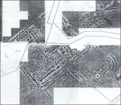
Geophysical survey produces a radar-like picture of features beneath the ground surface. What is even more exciting about the Llandeilo find is that there appear to be two forts on the same site, as well as a civilian settlement and other related features, including a Roman Road and a possible Roman bathhouse site. It is thought likely that the first fort dates to about AD 74, the time of the Roman conquest of Wales. [The Romans landed in Britain near Dover in AD 43, so they had reached Llandeilo in just 30 years]
It has a possible area of 3.9 hectares, which would make it one of the largest Roman campaign forts in Wales and may have housed a Roman legionary detachment. A second, smaller fort seems to have been built on the same site after the conquest and a small settlement grew outside its gates. The shadow of the first fort can be seen in the lower half of the image produced by the geophysical survey (below). The settlement outside the gates can also be seen in the upper right-hand quarter of the image.
Archaeologists will hopefully be able to carry out some excavation in the near future to try to begin to properly date and understand the features which are so clearly visible on the image shown here.
For more information visit the Cambria Archaeology website which contains more details, including the July 2005 excavation.
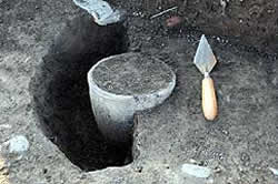
From June to July 2005 a three week archaeological dig of the Roman fort was undertaken as part of Channel 4's 'Big Roman Dig' TV project. On the first day an early first century AD funeral urn was discovered (see photo above). There appear to be two overlapping forts plus a vicus, or civilian settlement, dated from 75 AD to 120 AD.
2003 Geophysics of Llandeilo's Roman Fort. The curved and other lines are the various perimeter ditches and wall bases just under the field's surface. The shadow of the two forts can be seen in the lower part of the image produced by the geophysical survey (below). The settlement outside the gates can also be seen in the upper right-hand quarter of the image. The white areas in the image are parts the surveyors couldn't access.